Note: This article is sponsored by FarePilot. They’re a free app that provides drivers with locations and intel on where to go to get their next ride. I’ve found that it’s a useful app for when I don’t know where to go next after dropping off a passenger. Check it out here. As always, all opinions are our own.
Whenever I hear about AI and machine learning in the context of rideshare driving it usually involves how we are all going to get replaced by robots. This unfortunately paints AI and machine learning in a pretty negative light to drivers because it more or less becomes synonymous with “unemployment.” Even if drivers can benefit from it today.
AI and machine learning isn’t all doom and gloom for drivers though. It’s reflective of new technology; and like any new technology it’s benefit at the end of the day depends on how humans use it as a tool.
How Machine Learning Is Already Helping Drivers
FarePilot is a company that is presently using machine learning and advanced algorithms to “learn” where the busiest areas are in Los Angeles and London for drivers. Their algorithm takes into account factors like weather, live traffic, event & ticket sales, other drivers using their app, and human feedback to predict where it will be busy in the next 15 minutes.
This helps drivers answer an important question:
“Where Should I Go To Get My Next Ride?”
Let’s say you just dropped off a passenger in a suburb. You know that there are rides out there but you are also unsure of where to go to get them or how long it will take before you get a request. It’s tempting to drive all the way back to the busy area but it’s also a lot of unpaid “dead” miles. Do you stay and wait or do you go back to where it’s busy?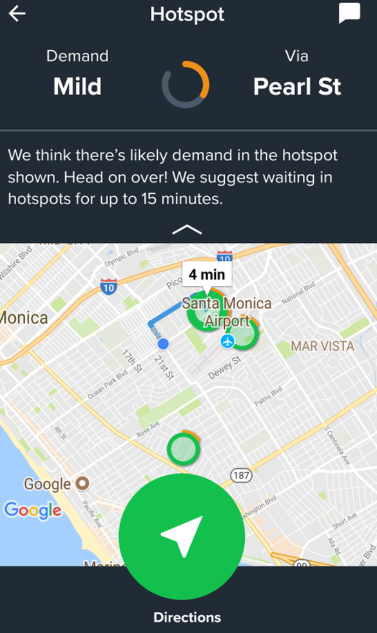
This is the problem that FarePilot is trying to solve. It gives you the three closest areas where it thinks you are most likely to get a ride within the next 15 minutes. The locations suggested are a reflection of how FarePilot’s machine learning algorithm has analyzed a lot of data in order to tip you off on where it will be busy before it’s even busy.
Should I Stay or Should I Go? : Move Your Hotspot To Find Out
You can also see how busy other hotspots are throughout the city by hovering the green pin throughout the map in the FarePilot app. Hotter hotspots display as orange or red and this helps make a decision on whether you should stay where you are or deadhead to the other side of the city where it’s busiest. It’s also a good way of figuring out new areas to “test” driving in since you can see the general activity level of any neighborhood without having to go there or wait for Surge/Primetime to appear on a map.
This makes life a little easier (while saving you some fuel) since you don’t have to deadhead back to a busy area. Also, most of the “hot spots” have a place to park nearby so that’s nice too 😉
What Makes a Hotspot on FarePilot?
Hotspots combine several streams of real-time data and “input” them into a live algorithm to suggest a place to go next, and a likelihood of how busy it will be. Most of the “inputs” are well-known to drivers but the app actually takes hundreds of thousands of examples of using that data to learn which combination of factors creates a formula for success.
Live Traffic and Commute Data

I think most drivers know that during rush hour that most rides come from areas that have a lot of traffic. We often have to weigh whether or not we can get to a request without sitting in 20 minutes (or more) traffic to get to them in the first place.
FarePilot uses map services to gather live traffic data and their hotspots take into account this live traffic data when providing a recommendation.
Events + Ticket Sales
We all know that big events draw in a lot of demand for rides, but there are often a lot of mid to small sized events that are even better because they aren’t known by most drivers. This translates into surge pricing and little to no traffic.
Part of FarePilots algorithm for their hotspots uses data gathered from ticketing and event agencies to gather insights on lesser-known events in real-time. It then mixes it in with the rest of its algorithm to build a hotspot.
Weather Patterns
When it’s beautiful and sunny people tend to leave their house (especially on the weekend). When it rains, it gets busier as people call cars to avoid getting wet. This is another major that is taken into account to reflect demand.
It Gets Smarter The More You Use It
Anecdotally, most drivers know that things like traffic, events, and weather are important factors in making their evening profitable. So it’s useful to have an algorithm that combines all of these things in real-time, using data we may not have (like smaller events) and then taking all of that data together to see how they relate to each other.
Supervised Learning
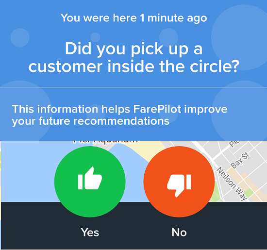
After drivers get a ride, they rate the location that FarePilot gave them with a “thumbs up” or “thumbs down”. This then actually teaches the program (or machine) in the app to suggest better locations. As it gathers more examples, it learns which factors result in a “thumbs up” and it gets better at combining those factors while eliminating “bad” factors. This is known as supervised learning.
My Thoughts On The App
I think FarePilot has a lot of ambition when it comes to helping drivers with data. Right now the app is focused on finding the nearest place to wait for a ride. However, I think it can actually end up doing a lot more in the future.
Simple and Useful
The app is very simple to use. You create an account, open the app, and click a green button to see the 3 closest hotspots to your location. Once you tap a hotspot in the app it will automatically load Google Maps or Waze and navigate you to it. The hotspots themselves are definitely placed around busy areas like train stations and commercial areas.
Just giving me a place to goto after dropping off the passenger is useful for me. Otherwise I have a tendency to wander around a bit (even though I know I shouldn’t).
Lots of Room To Grow
If I see the 3 closest hotspots have low demand, I definitely want to see what’s going on in the rest of the city. Having an app that provides unique intel on a wider level would help a lot. FarePilot has since upgraded it app to allow you to look at hotspots throughout the city to see where the most activity is.
Further, I might want to avoid going to a certain hotspot that the app thinks is “hot” because it was a “sold-out” event for the Competitive Vodka Drinking League. There may be “loads” of requests there but none of those people are getting in my car!
AI That Is Built For Drivers Instead of TNC’s
Rideshare companies have already been using AI and machine learning for a while now. They use it to build their heat maps, dispatch drivers and to predict how many drivers will be available at any given time. It’s pretty effective but one drawback is that it is designed to work in the company’s favor and not necessarily your bottom line.
FarePilot is an example of an app that’s built for driver’s which is using the latest in AI and machine learning to help drivers have a tool that benefits them.
You can download FarePilot here. It’s completely free to download and use (no subscriptions) and will help you find a place to go and hangout for your next ride after you drop-off a passenger.